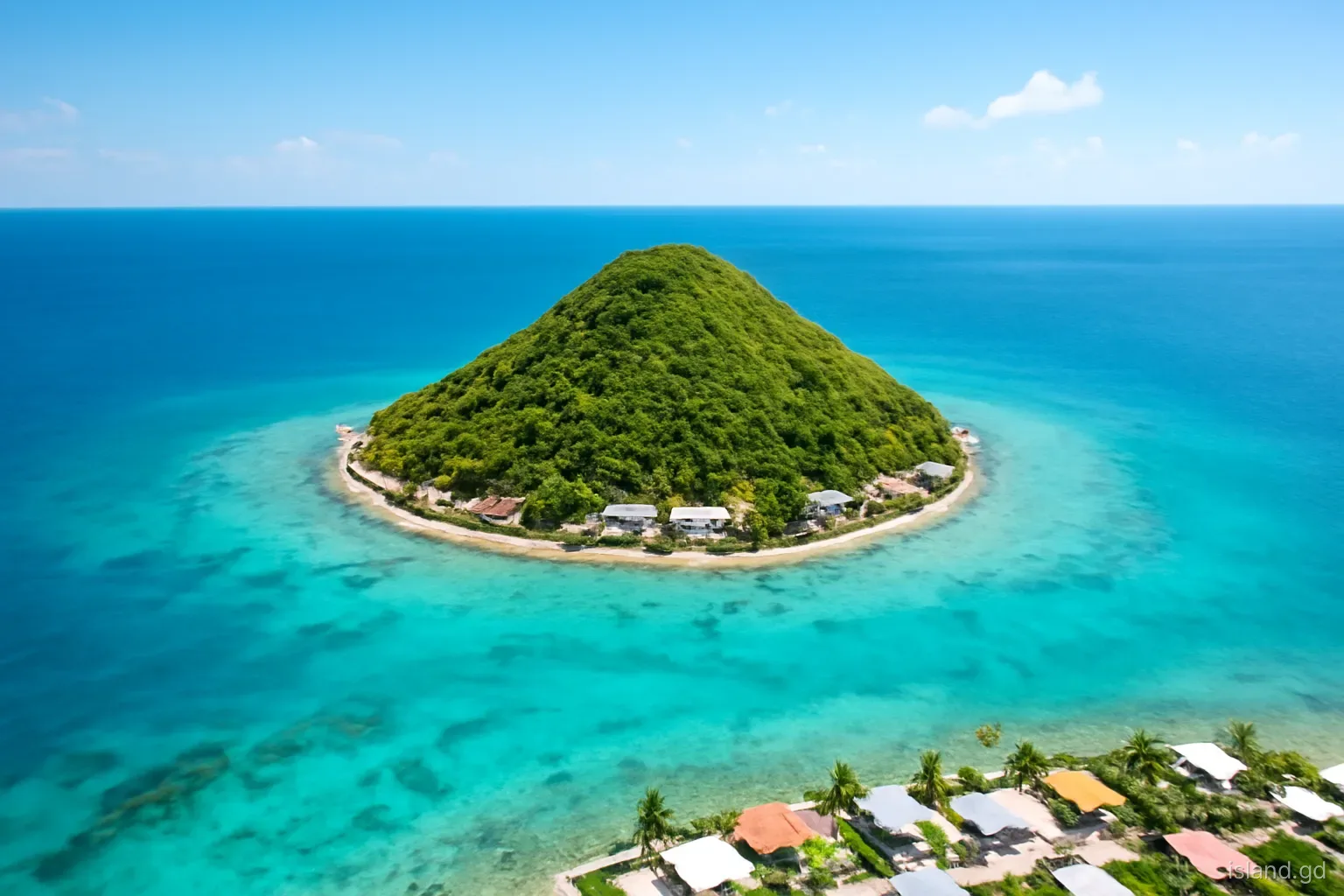
Petite Martinique is the smallest of the three inhabited islands that make up the state of Grenada, and almost everything about it follows from its size. The island covers roughly 2.4 square kilometres, about 590 acres, and a single steep hill, the Piton, takes up most of that area. Houses, boat sheds, churches and the jetty crowd onto the narrow strip of flatter land between the slopes and the sea.
It lies a few kilometres east of Carriacou's north-eastern shore, close enough that the hills of Windward look like a neighbouring parish rather than another island. On the far side, across a narrow channel, is Petit St Vincent, which belongs to St Vincent and the Grenadines. That border, a short swim's distance in places, shapes daily life more than most visitors expect.
This is a field guide to the island as a place: its shape, its plants, how the settlement sits on the land and how it differs from Carriacou. Population figures are usually given as somewhere around 900 to 1,000 people, though many more Petite Martinicans live abroad and count the island as home.
Where the island sits in the Grenadines
The Grenadines are a chain of more than thirty islands, islets and rocks running north from Grenada towards St Vincent. Grenada governs the southern part of the chain, including Carriacou, Petite Martinique and a scatter of small uninhabited islands; St Vincent and the Grenadines governs the rest, from Union Island and Petit St Vincent northwards. Petite Martinique is the north-easternmost inhabited outpost of Grenada, and the international boundary runs through the channel just off its shore.
From the island you can see a remarkable amount of the region on a clear day. Carriacou fills the western view, with the high ground of its northern ridge behind Windward. Union Island, with its jagged peaks, rises to the north-west. Petit St Vincent sits immediately across the water, and the small sand cays around it, including Mopion, catch the light further out. Looking east there is nothing but open Atlantic swell running in from Africa.
Locally the island is usually called PM, and people from it are Petite Martinicans. The name is commonly explained by early French settlement and an imagined resemblance to the much larger French island of Martinique to the north, but the two have no administrative link. Confusing them is a common mistake in online searches and even in some booking systems, so double-check any reservation that mentions Martinique.
The Piton and the shape of the land
The Piton is the defining feature. It rises steeply from close to the shore to a summit usually given at around 230 metres, which makes the island look from a distance like a cone set on the water. Its slopes are steep enough that most building stops at the foot of the hill, and the upper ground has traditionally been used for grazing goats and sheep rather than for houses or crops.
Like much of the southern Grenadines, PM is the worn-down remnant of ancient volcanic activity, shaped since then by wind, rain and the sea. The soils on the slopes are thin and stony. The coastline alternates between small sandy coves, cobble beaches and low rocky points, with fringing reef and seagrass in the shallows on the more sheltered side and rougher, more exposed water on the windward coast.
The summit can be reached on foot by paths that cross grazing land. They are steep, loose in places and not formally maintained, so the sensible approach is to ask residents which way to go, start early before the heat builds and carry water. The reward is a view over the whole of the southern Grenadines, with Carriacou, Union, Petit St Vincent and the open ocean laid out below.
A dry island: plants, water and weather
Less rain than the mainland. Grenada's main island has mountains that catch the trade-wind clouds and feed rivers and rainforest. Petite Martinique is too small and too low for that, so it receives far less rain and has no permanent streams. The dry season, roughly January to May, turns the hillsides brown and dusty.
Scrub and thorn. The natural vegetation is dry scrub: acacia-type thorn bushes, cacti, low trees and grasses, with sea grape and coconut palms along the shore. After the rains begin around June, the hills green up quickly and the island looks very different from the parched version seen in April.
Manchineel on the beaches. As elsewhere in the Grenadines, manchineel trees grow along some shorelines. Their sap and small green apple-like fruit are poisonous, and rain dripping from the leaves can blister skin. Do not shelter under unfamiliar shoreline trees in a shower, and never eat fruit you cannot identify.
Water from the sky and the sea. Households have traditionally relied on rainwater collected from roofs into cisterns, supplemented by desalinated water. Visitors should treat fresh water as a limited resource and use it sparingly, especially in the dry months.
The settled shore
Almost all of Petite Martinique's homes, shops and community buildings line the coast, with the densest settlement on the more sheltered side of the island around the jetty, where ferries and water taxis land. A road runs around much of the island close to the shore, and walking it is the simplest way to understand the place: houses with their backs to the hill, small boats drawn up on the sand, and slipways and work areas where vessels are built or repaired.
The houses tell part of the island's story. Many are solidly built in concrete, often two storeys, a sign of money earned at sea and sent home by relatives abroad over several generations. Hurricane Beryl in July 2024 damaged or destroyed a large share of them, so a walk today also passes repaired roofs, new construction and some empty shells still waiting for work.
Churches, the primary school, a health facility and a police presence sit within this same strip, so the whole community is within walking distance of everything. There is no airport, no bank branch on the scale of Carriacou's and no large hotel. That compactness is the island's character, not a lack of development waiting to be fixed.
Getting your bearings on foot
Because the hill fills the middle of the island, orientation on Petite Martinique is simple: keep the slope on one side and the sea on the other. Most visitors arrive at the jetty on the sheltered side, where the settlement is busiest, and can choose to walk in either direction along the shore road. The leeward stretches are calmer, with boats moored off the beach and views towards Petit St Vincent and Union Island; the windward side feels wilder, with stronger wind, rougher water and the open Atlantic beyond the reef.
Distances are short but the sun is fierce, and there is little shade once you leave the houses behind. Early morning and late afternoon are the comfortable hours for walking. Vehicles are few, but the road is narrow and has no pavement in most places, so walk facing oncoming traffic and keep children close. If you lose track of where you are, ask anyone: on an island this size, directions come with local history attached.
Petite Martinique compared with Carriacou
Visitors often lump the two sister islands together. They share history and family ties, but the differences are worth knowing before you go.
- Scale. Carriacou is roughly fourteen times larger, with several villages, an airport at Lauriston and a town in Hillsborough. On PM, one settlement band and one hill make up the whole island.
- Services. Carriacou has the Princess Royal Hospital, banks, supermarkets and customs and immigration offices. PM has basic shops and a health facility, and depends on Carriacou for most official business.
- Pace. Carriacou already feels slow compared with the mainland. PM is slower again, with fewer vehicles and a shoreline where most movement is on foot or by boat.
- Orientation. Carriacou looks to Grenada and Hillsborough. PM sits at the border and has long looked outward to the sea, to Union Island and to trade across the region.
- Mobile signal. Near the border your phone may pick up a network from St Vincent and the Grenadines. Check your roaming settings to avoid unexpected charges.
Frequently asked questions
How big is Petite Martinique?
The island covers about 2.4 square kilometres, roughly 590 acres. A steep central hill, the Piton, takes up most of that area, so the settled land is a narrow band along the coast. You can walk a good part of the shore road in a morning.
Is Petite Martinique part of Martinique?
No. Petite Martinique is part of the state of Grenada, alongside Grenada's main island and Carriacou. Martinique is a French territory much further north. The shared name is usually linked to early French settlement, but there is no political connection.
How high is the Piton on Petite Martinique?
The summit is usually given at around 230 metres. Paths to the top cross grazing land and are steep and loose, so ask residents for the best route, go early in the day and take water, a hat and sturdy shoes.
Can you see St Vincent's islands from Petite Martinique?
Yes. Petit St Vincent lies just across a narrow channel, and Union Island is clearly visible to the north-west. Both belong to St Vincent and the Grenadines, so visiting them requires proper immigration and customs clearance.
When is Petite Martinique greenest?
The hills are greenest during and after the rainy season, which usually runs from about June to December. In the dry months from January to May the scrub turns brown, the island looks parched and water is at its scarcest.