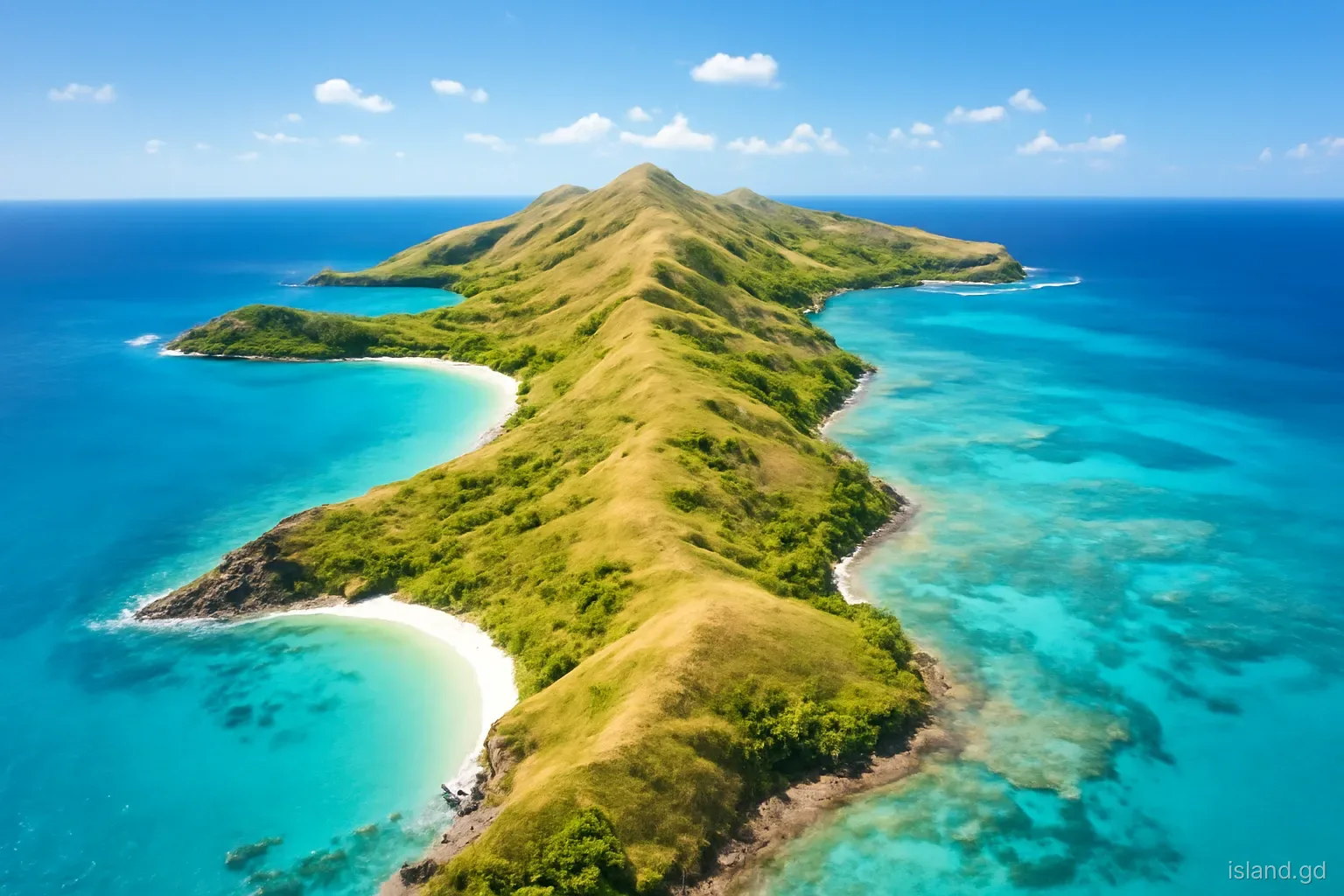
Carriacou is the largest of the Grenadines, the chain of small islands strung between Grenada and St Vincent, and the second island of the state of Grenada. It covers roughly 34 square kilometres, about 13 square miles, a fraction of the main island's size. Its name is usually traced to an Amerindian word meaning land of reefs, and the description still fits: coral fringes much of its coast and surrounds the islets offshore.
Arriving from the main island, the change in landscape is immediate. There are no towering rainforest peaks, no rushing rivers and no dense cocoa valleys. Instead, Carriacou is a ridge of rounded hills covered in dry forest and scrub, with sheltered bays on its western side and reef-lined shores to the east. In the dry season it can look brown and sun-baked; after the rains, it turns surprisingly green.
This article explains how Carriacou's landscape works, from its hills and coasts to its water supply and vegetation, and why the island feels so different from Grenada.
A ridge of hills from north to south
Carriacou is long and narrow, running roughly north-east to south-west, with a spine of hills along its length. The highest point, High North, rises in the north to around 290 metres and is covered in some of the island's best-preserved dry forest. The area is protected as a national park, and walking trails lead up through the woodland to views over the northern coast, Petite Martinique and the St Vincent Grenadines beyond.
Further south, the hills continue through the centre of the island. Chapeau Carré, a prominent rounded hill, is another landmark with wide views, and lower ridges separate the main valleys and villages. The slopes are generally gentle compared with the main island, but roads still climb and twist between settlements.
Geologically, Carriacou is older and more varied than the volcanic peaks of Grenada. Its rocks include ancient volcanic material along with limestone and marine sediments, and fossils have been found in some areas. Long exposure to erosion has worn the island into its present rolling shape.
Why Carriacou is so dry
Carriacou receives far less rain than the main island. Without high mountains to force moist air upward, passing clouds often drift over without releasing much. The island lies in a partial rain shadow, and the dry season, roughly January to May, can be long and parched, with hills turning brown and many trees shedding leaves.
There are no permanent rivers. Instead, steep gullies and ravines carry water briefly after heavy rain, then dry out. Fresh water has always been scarce, and the island's history is shaped by it: estates and households built cisterns to catch rain from roofs, and that tradition continues today, with most homes having a tank or cistern beneath or beside the house.
Public water supply has been supplemented over the years by desalination, which turns sea water into drinking water. Even so, water conservation is a habit on Carriacou in a way it rarely is on the wetter main island, and visitors are expected to use water carefully.
The sheltered west coast
Carriacou's western coast faces the Caribbean Sea and is sheltered from the trade winds. It holds the island's main bays and anchorages. Hillsborough, the main town, sits on Hillsborough Bay, with Sandy Island and Mabouya Island offshore. South of the town, L'Esterre Bay curves round past Paradise Beach, and further south still, Tyrrel Bay forms a deep, protected harbour beside the village of Harvey Vale.
These calm western waters made the west coast the natural focus for settlement, trade and boating. Jetties, fishing boats, yachts and the ferry landing all cluster here. The water is usually clear and gentle, with reefs and seagrass beds offshore.
Part of this coast falls within the Sandy Island Oyster Bed Marine Protected Area, created to protect reefs, seagrass and mangroves around Sandy Island, L'Esterre Bay and the mangrove lagoon at Tyrrel Bay. Rules on anchoring, fishing and taking marine life apply, with fees for some users, so boaters and divers should check current arrangements with the marine park office.
The windward east and the north
The eastern side faces the Atlantic and the trade winds. Here the coast is more exposed, with reefs offshore breaking the swell and creating lagoons inside them. Windward, the boatbuilding village in the north-east, looks across a reef-sheltered channel to Petite Martinique, while bays further south on the east coast are quieter and less developed.
The north end is rugged and wooded. Beaches such as Anse La Roche lie below steep, forested slopes and are reached by trail or by boat. Petit Carenage Bay, in the north-east, is fringed with mangroves and is an important habitat for birds and young fish.
Mangroves also grow in other sheltered spots around the island. They protect the shore from storm waves, filter runoff and serve as nurseries for reef fish, and their value became even clearer after Hurricane Beryl struck Carriacou in July 2024, damaging coastal areas and vegetation across the island.
Carriacou's place in the island chain
Carriacou sits on a shallow submarine platform that also carries the other Grenadines. Around it the sea is relatively shallow, which is why reefs, sandbars and small islets are so common, while deeper water lies to the west. A string of islets and rocks continues north-east towards Union Island and the other St Vincent Grenadines, and the international boundary between Grenada and St Vincent and the Grenadines runs through the water just north of Carriacou and Petite Martinique.
To the south, between Carriacou and the main island, lie Isle de Ronde, Caille and other islets, and also Kick 'em Jenny, an active submarine volcano on the seabed north of Grenada. It does not break the surface, but when its alert level is raised, the authorities set exclusion zones for shipping, which can affect boat routes between the islands.
This position on the edge of two nations has shaped Carriacou's culture. Families, trade and boats have moved freely between Carriacou, Petite Martinique and the St Vincent Grenadines for generations, and the island often feels as connected to its northern neighbours as to St George's.
What grows on Carriacou
Dry forest and scrub. The natural vegetation is dry tropical woodland: drought-tolerant trees, thorny shrubs, cactus and agave on rocky slopes. Many trees lose their leaves in the dry season and flush green with the rains.
White cedar. This tree, with pale pink flowers, is important locally and grows on the island, though boatbuilders have traditionally sourced timber for sloops from the main island and elsewhere as well.
Coastal plants. Sea grape, manchineel, mangroves and coconut palms line many shores. Manchineel is poisonous: its sap burns skin, its fruit is toxic, and sheltering beneath it in rain is unwise.
Crops. Small farms grow pigeon peas, corn, ground provisions and vegetables in the rainy season, and livestock such as goats, sheep and cattle graze across the island, often tethered or roaming.
Wildlife. Iguanas, tortoises, lizards, land crabs and a range of birds live on the island. Frigatebirds, pelicans and terns work the coast, and hummingbirds visit flowering shrubs.
Landscape mistakes visitors make
Carriacou's quiet landscape is easy to underestimate. These are the most common misjudgements.
- Expecting lush rainforest. Carriacou is dry, especially from January to May. Its beauty lies in hills, bays and reefs, not waterfalls and jungle.
- Underestimating the sun. With little shade on many roads and beaches, especially since Hurricane Beryl stripped trees, sunburn and dehydration come fast. Carry water and a hat.
- Ignoring manchineel. This coastal tree's sap and fruit are toxic. Avoid touching it, sitting under it in rain or eating its small apple-like fruits.
- Wasting water. Most homes and guesthouses rely on rainwater tanks or limited supply. Short showers and turning off taps are expected.
- Walking without planning. Trails such as those on High North are hot and exposed in places. Start early, tell someone your route and do not rely on finding water along the way.
- Damaging reefs and mangroves. Standing on coral, anchoring on reefs or cutting mangroves harms habitats that protect the island itself.
Frequently asked questions
How big is Carriacou?
Carriacou covers about 34 square kilometres, roughly 13 square miles. It is long and narrow, a few kilometres wide at most, and can be driven end to end in well under an hour. It is the largest of the Grenadines and the second island of Grenada.
What is the highest point on Carriacou?
High North, in the north of the island, is the highest point at around 290 metres. It is covered in dry forest and protected as a national park, with trails leading to views over Petite Martinique and the islands of the St Vincent Grenadines.
Does Carriacou have rivers?
No, Carriacou has no permanent rivers. Gullies and ravines carry water only briefly after heavy rain. Households depend mainly on rainwater collected from roofs into tanks and cisterns, supplemented by public supply, including desalinated sea water.
What does the name Carriacou mean?
The name is usually traced to an Amerindian word often translated as land of reefs. The description suits the island, which is surrounded by fringing coral reefs, seagrass beds and reef-ringed islets such as Sandy Island, White Island and Saline Island.
Why is Carriacou drier than Grenada?
Carriacou lacks the high mountains that make the main island so wet. Moist trade-wind air passes over its low hills without rising enough to produce heavy rain, so it receives much less rainfall and has a longer, harsher dry season.