From the air, Grenada's mangroves look like thin green fringes around a few bays and lagoons. Up close they are dense, tangled forests standing in salt water, their arching roots sheltering fish, crabs and oysters. They slow waves, trap sediment, filter runoff and store large amounts of carbon in their mud. During hurricanes, sailors have long sought shelter among them, and in Carriacou, Tyrrel Bay's mangroves are known as a traditional hurricane hole.
Mangroves have been cleared for development, roads and marinas, and polluted by runoff and dumping. Hurricane Beryl in 2024 caused heavy damage to mangroves on Carriacou and Petite Martinique. Yet these forests are among the most valuable natural defences small islands have against rising seas and stronger storms. This article explains where they grow, why they matter and what is being done to protect them.
What mangroves are
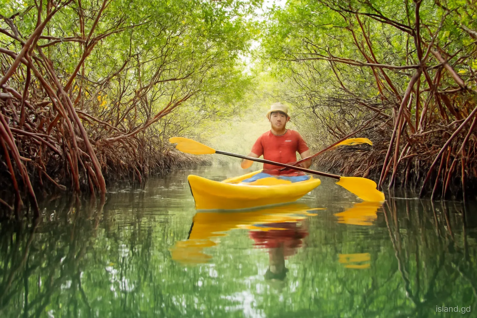
Mangroves are trees and shrubs adapted to grow in salty, waterlogged coastal soils. In the Caribbean, several species occur together, usually in zones. Red mangrove, with its arching prop roots, grows at the water's edge. Black mangrove, with pencil-like breathing roots called pneumatophores rising from the mud, grows slightly inland. White mangrove and buttonwood occupy higher, drier ground.
Their roots stabilise soft sediments, while the trees tolerate salt by filtering it at the roots or excreting it through leaves. Fallen leaves feed a food web of microorganisms, crabs and fish, making mangrove areas highly productive.
Mangroves grow where conditions are calm: sheltered bays, lagoons and river mouths. In Grenada, that means mainly the south and east coasts of the mainland and sheltered bays on Carriacou, rather than the exposed Atlantic beaches or the deep water of the west coast.
Grenada's mangrove area is small compared with larger Caribbean countries, which makes each remaining stand more important. A strip a few dozen metres wide around a lagoon may be the only buffer between a village road and the sea, and the only nursery habitat for fish along that stretch of coast. Losing even a modest patch can have effects out of proportion to its size.
Where to find mangroves
Mangroves occur in scattered patches around the islands. Notable areas include:
- Levera, St Patrick. Levera Pond and its surrounding wetland, within a protected area at the north-eastern tip of the mainland, include mangroves and attract water birds.
- South-coast bays. Inlets such as Woburn, Clarks Court Bay and parts of the Calivigny and Westerhall area have mangrove fringes, some within the Woburn Clarks Court Bay marine protected area.
- La Sagesse, St David. The coastal area near La Sagesse includes a salt pond and mangroves alongside the beach.
- Tyrrel Bay and the Oyster Bed, Carriacou. The mangrove-lined lagoon in Tyrrel Bay is part of the Sandy Island Oyster Bed marine protected area and has long served as a hurricane hole.
- Petit Carenage and the north-east of Carriacou. Mangroves near Petit Carenage Bay and around the north-east coast fringe lagoons and support birdlife.
- L'Esterre and other Carriacou bays. Smaller stands around other bays add to Carriacou's mangrove cover.
Why mangroves matter
Storm protection. Dense mangroves reduce wave energy and storm surge, protecting coastlines, roads and homes behind them. Their effectiveness depends on width and density.
Nurseries for fish. Many reef and commercial fish species spend their juvenile stages among mangrove roots, safe from predators. Healthy mangroves support fisheries.
Water quality. Mangroves trap sediment and absorb nutrients from runoff, keeping coastal waters clearer, which benefits seagrass and coral reefs.
Blue carbon. Mangrove soils store carbon at high densities, often for centuries. Protecting and restoring mangroves helps keep carbon out of the atmosphere.
Livelihoods and culture. Mangrove oysters, crabs and fish have long been harvested locally, and the Oyster Bed in Carriacou takes its name from oysters growing on mangrove roots.
Hurricane holes. Sailors shelter boats in mangrove-lined lagoons during storms, as in Tyrrel Bay, though shelter is not guaranteed in an extreme storm.
Wildlife to look for
Herons and egrets. Green herons crouch on low roots waiting for small fish, while great egrets and other white herons wade the shallows. Night herons roost in the branches by day.
Kingfishers. Kingfishers perch over channels and dive for fish; the belted kingfisher is a regular winter visitor to the Caribbean.
Crabs. Fiddler crabs wave their oversized claws on exposed mud at low tide, and mangrove tree crabs climb the trunks and roots.
Juvenile fish. Look down into clear water among the prop roots to see schools of small fish, including young snappers and barracuda that will later move to the reefs.
Upside-down jellyfish. In still, sunny lagoons, pulsing jellyfish lying on the bottom, bell down, are a common sight. They can sting mildly, so avoid touching them.
Oysters and sponges. Oysters, sponges and algae grow on submerged roots, forming colourful communities that are best admired without touching.
Threats to Grenada's mangroves
Clearing for coastal development, marinas, roads and housing has removed mangroves in many Caribbean islands, including parts of Grenada. Once cleared, mangroves rarely return unaided, because the land is filled, hardened or dredged.
Pollution is another threat. Runoff carrying sediment, fertilisers and sewage, illegal dumping of waste and oil spills from boats damage mangroves and the life they support. Changes in water flow, from roads cutting off lagoons or blocked channels, can starve mangroves of tidal exchange.
Climate change adds pressure. Rising seas can drown mangroves if they cannot migrate inland, especially where development blocks them. Stronger hurricanes strip and uproot trees. Hurricane Beryl caused severe damage to mangroves on Carriacou and Petite Martinique, and recovery will take years.
Even small, everyday actions add up. Cutting a few trees for a jetty or a view, dumping construction rubble at the edge of a lagoon or letting boats run aground on roots slowly fragments a stand until it can no longer protect the shore or support wildlife.
Restoration and protection
Restoration projects in Grenada and Carriacou have planted mangrove seedlings, restored water flow and worked with communities to protect existing stands. Some have been part of wider climate adaptation programmes, including work supported by international partners on integrated climate change adaptation in Grenada.
Successful restoration depends on understanding why mangroves disappeared in the first place. Planting seedlings where water flow, salinity or elevation is wrong often fails. Restoring tidal channels, removing debris and protecting areas from further damage can let mangroves recolonise naturally.
Protection through marine protected areas, planning controls and community stewardship is often cheaper and more effective than restoration. Including mangroves in coastal planning, rather than treating them as wasteland, is a key step for long-term resilience.
After Beryl, mangrove recovery became part of the wider rebuilding conversation on Carriacou. Community groups, schools and environmental organisations have taken part in clean-ups and replanting, and monitoring which damaged stands regrow on their own helps target effort where it is needed.
Visiting mangroves responsibly
Mangroves are rewarding places to explore by kayak, paddleboard or on foot along their edges. To visit without harm:
- Go with a local guide or operator where possible, who knows the channels, tides and wildlife.
- Stay in open water channels and avoid pushing through roots, which damages young plants.
- Do not anchor boats in mangroves or tie lines to trees unless in a designated hurricane mooring.
- Avoid touching or collecting oysters, crabs, birds or plants.
- Use insect repellent and cover up; mangroves are home to mosquitoes and sandflies.
- Take all rubbish out with you and pick up litter if you can do so safely.
- Report illegal dumping or clearing to the Fisheries Division or relevant authorities.
- Time your visit for calm weather and a rising or high tide, when channels are easier to paddle and you are less likely to ground on mud or roots.
Frequently asked questions
Where are mangroves in Grenada?
Mangroves grow mainly in sheltered bays and lagoons on the south and east coasts of the mainland, including Levera, Woburn, Clarks Court Bay and La Sagesse, and on Carriacou around Tyrrel Bay, the Oyster Bed, Petit Carenage and L'Esterre. They are absent from exposed beaches and deep water.
How do mangroves protect against hurricanes?
Dense mangrove forests slow waves and reduce storm surge, protecting coastlines behind them. Their roots also stabilise sediment, limiting erosion. They cannot stop every effect of an extreme storm, but wide, healthy mangroves significantly reduce damage compared with bare shorelines.
Were Carriacou's mangroves damaged by Beryl?
Yes. Hurricane Beryl in July 2024 caused heavy damage to mangroves on Carriacou and Petite Martinique, stripping and uprooting trees in areas such as Tyrrel Bay and Petit Carenage. Some may recover naturally over time, while others may need restoration work.
What is blue carbon?
Blue carbon refers to carbon stored in coastal ecosystems such as mangroves, seagrass meadows and salt marshes. Mangrove soils can hold large amounts of carbon for centuries. Protecting and restoring them helps reduce greenhouse gases while supporting coastal resilience.
Can you kayak in Grenada's mangroves?
Yes. Guided kayak and paddleboard trips explore mangrove areas, including in Carriacou and on the south coast of the mainland. Stay in channels, avoid touching roots and wildlife and go with a local guide who knows the tides and protected-area rules.
Why is it called the Oyster Bed in Carriacou?
The Oyster Bed in Tyrrel Bay takes its name from mangrove oysters that grow attached to the prop roots of red mangroves. The area is part of the Sandy Island Oyster Bed marine protected area and serves as a nursery for marine life and a traditional hurricane hole.